I’ve been talking to a few friends about the iOS 6 maps; specifically what they added, what they took out, and who’s gonna be mad as heck about it.
“A step back”
A friend of mine keeps using that phrase to describe the new Maps app, but I don’t think that’s entirely right. For those that haven’t heard about the changes yet, they’re switching to using their own data instead of Google Maps data, adding turn-by-turn directions, and real-time traffic information and possibly most importantly, removing transit directions. For transit directions in iOS 6, other apps can register as transit apps for various cities, and it’ll present you with that list of apps when you’re in a city and you need transit directions.
Apple historically doesn’t like to be reliant on a company the way they were with Microsoft with Office and Internet Explorer or the CodeWarrior folks back in the day, so they made iWork, Safari, and Xcode, just so they could update those at their own pace. In that vein, the disuse of the Google maps tiles seems really straightforward, but I think there’s more going on.
Transit
The removal of transit routing from the new app is a huge mistake. All of that data is available already openly available for most cities (because it powers the Google maps transit routing). You can read about that specification here. If I had to guess, I’d say it was only an issue of time that caused it to get left out in iOS 6. I’d be incredibly surprised if it weren’t back in iOS 7.
Turn-by-turn
Android got turn-by-turn directions almost 3 years ago, and it seems that Apple just wasn’t allowed to take advantage of that kind of functionality from Google, for some reason. To gain any new features at all, it seems, the deal with Google had to be completely broken, and a new Maps infrastructure would have to be built. So they did, and it took them a few years, but now we have turn-by-turn and real-time traffic data at the expense of transit directions, and data density.
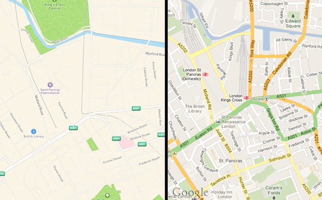
By now you’ve certainly seen an image like this:
I prefer the Google map for sure. Better information density, more clear, generally richer. The problem for Apple here is data. Before Google maps, basically one company had any kind of digital map data that they were willing to license, and that was Navteq. They powered Mapquest, Yahoo! Maps, Google Maps, and anyone else trying to play in the market. However, in the mid-2000s, Google made a really smart decision and outfitted cars with cameras and GPSes, and they went around the country collecting not only street view information, but also street information. This let them build up their own map graph, and made them no longer reliant on Navteq, and let them do whatever they wanted with the data, including turn-by-turn (disallowed by the Navteq licensing terms).
Which brings me to the possibly most interesting about the new Maps in iOS 6, which is the real-time traffic data. If traffic data is really being captured from all iPhones (while they’re doing turn-by-turn only, I’d imagine, just so they could save a little battery life), they would have an incredibly rich dataset of how big roads are, which directions they go in, when new streets are put up, and when old streets are blocked off, and if they could get this data from Waze (who is their partner for the real-time traffic technology) they could build a map dataset to rival Googles, and then they could enable the richness of context that Google provides for its map tiles.
Apple’s certainly is not a data company, but they definitely seem to be moving in that direction, with Siri (which needs a tremendous amount of voice data to be accurate) and possibly these new maps, and that could be exciting.

